Home » Products » Measuring Instruments » Distance Meters » Laser Distance Meters » Leica DISTO X3 Laser Distance Meter
Leica DISTO X3 Laser Distance Meter
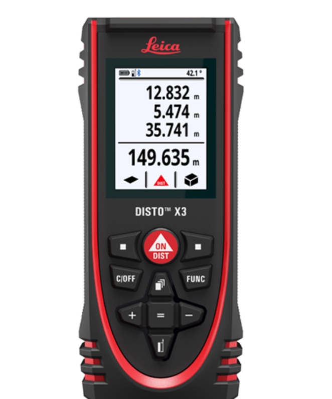
The new Leica DISTO X3 Laser Distance Meter is the only laser distance meter to be dust-tight and protected against water jets – to IP65. In addition, it passed drop tests of up to 2 meters, and can now measure up to 150 meters. Thanks to the integrated tilt sensor with rotatable display, it makes taking awkward measurements easier and more ergonomic. It also has Bluetooth® so you can transfer your measurements to your computer or tablet—and you can use it with the DISTO Plan App for iOS and Android. Leica DISTO X3 Laser Distance Meter – guarantees reliable measurements, even under the harshest conditions. Robust Housing The sensitive measuring elements are protected by solid rubber parts. Proven in drop tests from up to 2 m height, the Leica DISTO X3 Laser Distance Meter is therefore particularly resistant. Protection Class IP65 Tilt Sensor 360° Smart Horizontal Mode™
Product Description
The housing and keypad are specially sealed against water and dust. Cleaning under running water is also no problem.
Thanks to the combination of distance and tilt measurements, you can determine the horizontal distance absolutely precisely and simply – even past obstructions. With the help of the tilt sensor, you can also determine indirect heights.
If obstructions prevent you from taking direct distance measurements, you can use the Smart Horizontal Mode™ to determine the horizontal distance simply and absolutely precisely.Specifications
Part Number Description Typ. distance measuring accuracy ± 1.0 mm / 0.04 in Range 0.05 up to 150m Measuring units m, ft, in X-Range Power Technology yes Distance in m 10, 50, 100 m Ø of the laser dot in mm 6, 30, 60 mm Tilt sensor yes Tilt sensor accuracy to the laser beam ± 0.2° Tilt sensor accuracy to the housing ± 0.2° Units in the tilt sensor 0.0°, 0.00 % Measuring range with DST 360 Horizontal 360° Vertical −64° to > 90° Distance in m 2, 5, 10 m Typ. tolerance of the P2P function with DST 360 ± 2, 5, 10 mm Levelling range with DST 360 ± 5° Memory for last measurements 20 Display illumination yes Free software for Windows yes Free App for iOS and Android yes Smart Room support yes General data interface Bluetooth® Smart Data interface for 3D point data with DST 360 Bluetooth® Smart Measurements per set of batteries up to 4,000* Service life of batteries up to 8 h* Multifunctional endpiece yes Automatic reference detection for endpiece yes Tripod thread 1/4″ Batteries type AA 2 × 1.5 V Protection class IP65 2 m drop tested “applies to the DISTO device” Yes Dimensions 132 × 56 × 29 mm (H x D x W) Weight with batteries 184 g Packing List
Data Sheet
Instruction Manual
Comparison Table
Which instrument is the right one for me?
D1 D110 D2 X3 D5 X6 Digital Pointfinder for outdoor measuring x x Max. range 40m 60m 100m 150m 200m 250m General Accuracy ± 2mm ± 1.5mm ± 1.5mm ± 1mm ± 1mm ± 1mm P2P function x* x* Extra durable housing with IP65 and 2 m drop-tested x x Wireless interfaces (low energy) Bluetooth® 4.2 Bluetooth® 4.2 Bluetooth® 4.2 Bluetooth® 4.2 Bluetooth® 5 Bluetooth® 5 Computer Interface Data transfer to DISTO Plan and DISTO compatible apps x x x x x x Data transfer to any software or app x x x Download data via USB-C interface x Distance measurement from device x x x x x x Distances Dimensional measurements on objects x x x x x x Indirect distance measurement over obstacles x x x P2P function – any distance between 2 points x* x* Rectangular shapes (length and width) x x x x x Areas P2P – Smart Area function for complex shapes x* x* Measure in picture – facades, vertical boards x Volume Rectangular shapes (length, width, height) x x x x Using Pythagoras Theorem x x x x Widths Measure in picture – width measurement x P2P function x* x* Smart functions using distance and inclination for calculation x x x Heights Height profile x x P2P function x* x* Inclinations x x x Slopes Smart functions using distance and inclination for calculation x x P2P function x* x* Measuring in picture – diameter of objects x Continuous measurement – tracking x x x x x x Diameter Stake out x x x x Positioning P2P – DXF data capturing on device x Draw and measure (floor) plans x** x** x** x** x** x** P2P – point capturing for floor plans and facades x*** x*** Smart Room – measure and draw x** x** x** PDF, JPG and DXF exports x** x** x** x** x** x** Planning and Measure and document on pictures x** x** x** x** x** x** Documentation P2L — documenting positions based on a reference line x Creating measurement reports (JPG and CSV) x Touchscreen x Trigger measurement with gestures x x Favourite keys x x x Automatic end piece x x x x Usability Keyboard mode x x x